|
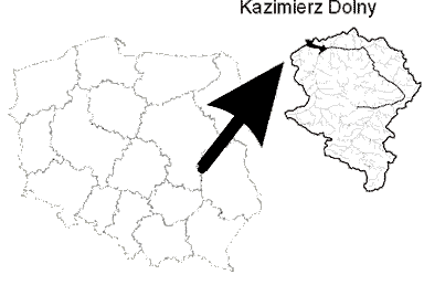
The research area presents
the upland watershed of Grodarz stream, located in junction of three
phisiographic  regions:
Naleczow Plateu, Belzycka Plain and Malopolski Vistula Gorge. It's
a relatively small watershed with area of about 3000 ha. The reach
and diverce landscape of the northen part of the watersheds is located
on Naleczow Plateu on deep loess and silty soils overlaying calcarous
bedrock - an area cut by various forms of gullies in various development
stages (total length of about 56km). The specifics of the town Kazimierz
Dolny, known as "the polish perl of the renesaince", localised
at the outlet of the Grodarz watershed appears also in the history
of most of the gullies, which have their own names (for example
Norowy Deep, Chołajowy Depp or Root Deep) and often dated history.The
existancee of gullies and steep slopes is acoompanied by surface
water erosion and sporadically by suffosion as well as locally by
mass movements. Gullies also heavy influence watershed's hydrology,
accelarating surface flow and deminishig water retention of adjacent
plots. In the history of Kazimierz Dolny occured sporadicall, but
very intensive, mud flows accompanying cloudburstes and intensive
snow melting. One of such disasters appeared in Kazimierz Dolny
on April, 25, 1976 (I=40mm/h, t=1h), when the marketplace of Kazimierz
Dolny was covered by about 50cm layer of sediments. regions:
Naleczow Plateu, Belzycka Plain and Malopolski Vistula Gorge. It's
a relatively small watershed with area of about 3000 ha. The reach
and diverce landscape of the northen part of the watersheds is located
on Naleczow Plateu on deep loess and silty soils overlaying calcarous
bedrock - an area cut by various forms of gullies in various development
stages (total length of about 56km). The specifics of the town Kazimierz
Dolny, known as "the polish perl of the renesaince", localised
at the outlet of the Grodarz watershed appears also in the history
of most of the gullies, which have their own names (for example
Norowy Deep, Chołajowy Depp or Root Deep) and often dated history.The
existancee of gullies and steep slopes is acoompanied by surface
water erosion and sporadically by suffosion as well as locally by
mass movements. Gullies also heavy influence watershed's hydrology,
accelarating surface flow and deminishig water retention of adjacent
plots. In the history of Kazimierz Dolny occured sporadicall, but
very intensive, mud flows accompanying cloudburstes and intensive
snow melting. One of such disasters appeared in Kazimierz Dolny
on April, 25, 1976 (I=40mm/h, t=1h), when the marketplace of Kazimierz
Dolny was covered by about 50cm layer of sediments.
Gullies present undoubtedly
the threat for the Kazimierz Dolny town, although they shape its
rare specifics and climate. The truth is, that without gully erosion
forested areas wouldn't exist on the fertile loess uplands! Climatic
and healthy virtues of the fresh forestial habitats overgrowing
gullies' slopes, rare and protected species of animals and plants
as well as emerging here and there history of this area and Kazimierz
Dolny - the perl of the renessaince build the landscape of the Grodarz
watershed - landscape, which must be curbed sometimes, but above
all protected.
|

